By Kenn Taylor
It’s 8am on a mild February morning when I meet Stephen McCoy and Stephanie Wynne near Liverpool city centre. We are en route to the Peak District via the infamous Snake Pass. “There’s an element of the unknown,” says Stephen, as we drive out towards the M62. “You have a map but you’re not exactly sure. It requires a bit of detective work. Some have been removed, others are on restricted sites, but we want to document that variety.”
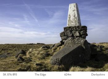
We are heading out to find ‘trig point’ number 25 of photography partnership McCoy Wynne’s long-term project, Triangulation. Trig points, or to give them their correct name, triangulation pillars, are concrete or stone pillars of about 4 feet in height which were used by the Ordnance Survey to generate an accurate picture of the shape of the British Isles. Approximately 6,500 of these pillars were spread across the UK, from as far north as The Shetland Islands to the southern tip of the UK near Lands End. Of these, just over 300 were ‘primary’ trig points. McCoy Wynne have made it their mission to photograph a panorama from the top of all these primary points.
The speed of the motorway network means we move from Merseyside to Derbyshire in a short space of time, but things are about to get a lot slower. Parking in a lay-by on the Snake Pass, we set out on the Pennine Way footpath. Travelling from the mild temperatures of the lowlands, it is surprising just how cold it is up in the Peaks. The level of snowfall can be seen by the deep footprints left by past visitors. Now though, the snow is frozen solid and even booted feet make virtually no impression on its hard surface.
Trig points were used by fixing a theodolite on the top of the pillar so that accurate angles could be measured to other surrounding points. This allowed the construction of a system of triangles that could then be referenced back to a single baseline. Trig points are generally located at the higher points in an area, so that there is a clear view from one pillar to another. You may have seen them on a country walk many times and never noticed them or thought of their function. As for myself, until this project I assumed they simply marked the highest point on hills and mountains.

We have some way to go before we reach our particular trig point on ‘The Edge’, not far from Kinder Scout. As we walk the Pennine Way the noise of the traffic gradually fades and the sound of the wind comes to dominate. It’s so cold I have to write speedily as, after only a few minutes with my gloves off, my hands go numb and I struggle even to unzip my pocket to put my notebook back in.
The trig points McCoy Wynne are photographing date back to ‘the Retriangulation of Great Britain’ instigated in 1935 by the Ordnance Survey. The aim of this project was to replace the original triangulation of Britain, known as the Principal Triangulation, undertaken between 1783 and 1853, with a more modern and accurate one. This was an immense task that would continue until the 1960s. The results of the retriangulation were used to create the British national grid reference system that is still used as the basis of maps today and allows the plotting of the entire country with relative accuracy.
As we begin to head up towards Kinder Scout, the snow fringes all of the surrounding dark hills. It is just possible though to see the shape of Manchester’s Beetham Tower in the distance through the fog, showing just how near to the urban bustle such isolation and desolation is. Kinder Scout was of course the scene of the famous Mass Trespass in 1932 when walkers from the nearby industrial towns and cities of the North asserted their right to access public rights of way. We owe them a lot.
The triangulation method of surveying has now been rendered obsolete by satellite-based GPS measurements. As a result the trig point network is no longer actively maintained, except for a few points that have been reused as part of the Ordnance Survey’s National GPS Network. The remainder now merely unnecessary, and in many cases decaying, marks of the landscape.
Erecting new trig points and making measurements frequently required materials and equipment to be carried on foot, up hills and mountains and to isolated islands, in all kinds of conditions. In the search for our trig point, the terrain gets harder as we start climbing steeper upwards. At some points we almost have to scramble on all fours in the snow and ice with large cameras and bags. A small reminder of the sheer amount of effort and labour the people who created this network would have had to go through.

Having covered most of North West England and North Wales, this trig point will be one of the last within easy travelling distance of McCoy Wynne’s home. “As we need to travel further we will have to plan more carefully,” says Stephanie. “We hope to combine shooting trig points elsewhere in the country with our commercial photographic work, to help cover some of the costs of travel.” Stephen and Stephanie have been working together as professionals for 16 years, 8 of those full-time, specialising in photographing architecture, the built environment and landscapes.
The creation of the entire triangulation network took from 1936 until 1962, with a gap for the Second World War. McCoy Wynne hope the duration of their project will be a little shorter. Their intention is to complete their work in the next 5 years and find venues to exhibit the photographs close to each geographical area they complete. “It will never be finished really,” says Stephen, referring to all the non-primary trig points they do not plan to shoot. The remaining ones of which number nearly 6,000.
I ask them, how did this substantial mission start? “Photography is suited to big projects and we have always been interested in maps and the traditions of landscape photography,’’ says Stephen. ‘We were looking for a way of photographing the landscape in which the photographers’ decisions became reduced, objectifying rather than romanticising the landscape.”
Stephen continues: “The first was Beacon Fell, Trough of Bowland, which isn’t a primary trig point.” It was here they experimented with different ways of shooting the project. Their chosen method is systematic, perhaps appropriate for photographing something which mathematically divided up the country. “We place the tripod on top of the trig point,” says Stephanie, “and shoot a full panorama. So the only aesthetic decision we make is where to start and end the panorama when we display it.” Stephen adds: “It seemed like the natural way to do it. Most of the effort is in getting to the trig point. It’s usually a quick process when we get there.”
Effort is something we’re becoming more aware of in our current search. Despite the cold, which we were well prepared for, we have been bowled over by the scenery, especially a de-tour to see the frozen Kinder Downfall waterfall, but now we’re keen to find the point, shoot it, and get back to the car for coffee. Yet it is proving elusive.

The Ordnance Survey, as its name suggests, had its origins in the military. Mapping is to an extent is about power and control. Thoughts again turn to the Kinder Trespassers, or even Google’s Street View, which has mapped the UK in its own way in just a couple of years, a corporation rather than a government now seemingly having the power of map making.
Stephanie though points out the desire people had to exert control over the landscape long before even trig points: “These places, miles from anywhere, were still given names by local people so things could be defined. Farmers had to know where the sheep were!”
We continue to search for the Kinder Scout trig point for some time, consulting maps and even asking a few passers-by, but to no avail. In the end, we happen upon a couple of National Park Rangers, keeping an eye on people in the adverse conditions. They tell us we’re a long way off and warn of a ‘white out’ soon. With the snow getting heavier and light declining, McCoy Wynne decide to come back another day.
Stephen says: “It’s the first in 25 we’ve not found!” It would of course be the one time they had taken me with them. The Park Rangers also tell us that due to the erosion of the peat around the trig point, it’s now six feet from the ground. “Oh we’ll have to shoot that one,” says Stephanie. Indeed, they will return to photograph again a couple of weeks later, their previous scouting efforts and less inclement weather, making the trig point this time, much easier to find.
Triangulation may be about the mathematical shape of the UK, but McCoy Wynne’s project will show the visual shape. A photographic survey of Britain’s varied landscape, from the picturesque to the industrial, the desolate to the bustling. The power of such scenery can never be truly appreciated from just looking at the lines on a map. McCoy Wynne’s work is also a celebration of the efforts of those whose quiet, methodical precision in the face of the elements has helped millions of people to explore the landscape and that, on a good day, helps us find what we are looking for.

This piece appeared in the catalogue to accompany the Processing photography exhibition, held at the Conerstone Gallery in Liverpool from 7th June – 29th September 2013.
Images Copyright McCoy Wynne. Text Copyright Kenn Taylor.
